
This section is currently a work in progress
Research Locations:
- Site Map & Data (click on a location tag to retrieve associated list of data)
- GIS-VA-PIEGIS - Data file of research site locations
- Research sampling areas throughout the Plum Island Ecosystems study area. Click for more information:
- Watershed Sampling Sites Marsh Sampling Sites Benthic Sampling Sites Long-Term Monitoring Sites
Maps:
- PIE LTER Google map
- Map of Plum Island Sound and the Surrounding Estuarine System
- Watershed Map with the Ipswich, Parker, and Rowley Rivers
- 1971 Land Use Map
- 1985 Land Use Map
- Map of Plum Island Sound Streams, Ponds, and Watersheds
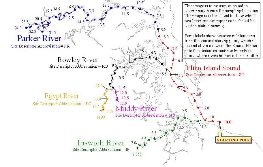
- NOAA map of Newburyport Harbor and Plum Island Sound Map of riverine kilometer and site descriptor abbreviations
Aerial Imagery:
Infrared aerial photo of the mouth of the Parker River and Northern Plum Island Sound, Newbury, Massachusetts, 1:25,000 scale, Flown in July 1985 by James W. Sewall, Old Town, ME for University of Massachusetts, Amherst, MA.
Color aerial photo of Plum Island Sound and surrounding estuarine system, Ipswich, Rowley and Newbury, Massachusetts, March 1992, 1:40,000 scale, USGS National Aerial Photographic Program.